AboutTermsPrivacyContact
 
Updating
London Maps Offline

London Maps Offline

Released: 2015-02-10
Contains Ordnance Survey, Royal Mail and National Statistics data © Crown and Royal Mail copyright and database right 2014/5. Contains Database of British and Irish Hills
London Maps Offline - QR Code
Version 2.0.0
4+
Download on the App Store
Version 2.0.0
4+
Download on the App Store
Released: 2015-02-10
Contains Ordnance Survey, Royal Mail and National Statistics data © Crown and Royal Mail copyright and database right 2014/5. Contains Database of British and Irish Hills

iPhone Screenshots

Screenshot
Screenshot
Screenshot
Screenshot
Screenshot
Screenshot
Screenshot
Screenshot
Screenshot

iPad Screenshots

Screenshot
Screenshot
Screenshot
Screenshot
Screenshot
Screenshot
Screenshot
Screenshot

Description

From the producers of GB Maps (featured in Ordnance Survey's OS OpenData innovative application showcase)
Beautifully detailed maps supplied by Ordnance Survey.
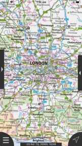
London Maps Offline provides a useful offline mapping reference and navigation aid whilst travelling throughout London by roadside, road, rail, canal, lake and river.  A powerful offline search facility can locate places, roads, post codes and hills within the region.  It also provides worldwide online Apple maps (Standard, Satellite and Hybrid).  Map features that you are used to with Apple maps are available on both offline and online maps as well as providing 3D buildings on Apple maps (where available).
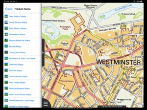
Maps
- 7 different levels of offline 2014/2015 Ordnance Survey map detail from national overview to street view within the region. (No data connection required)
Progressively more detailed maps are automatically loaded as the map view is zoomed.  The maps seamlessly transition from one level of detail to the next. The OS recommended viewing scales for the more detailed maps are approximately as follows:
1:1000,000 (Whole of GB)
1:250,000
1:50,000
1:25,000
1:10,000 (Roads/streets are labelled)
The map region of the more detailed maps covers a rectangular region around the M25 orbital motorway (ref. http://jomosolutions.com/Maps)
London Underground stations, hospitals, airports and other features are marked on some of the more detailed maps.
App
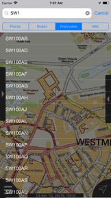
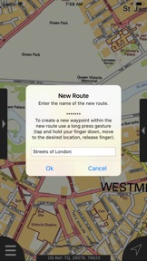
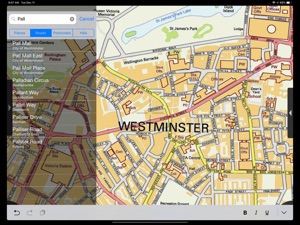
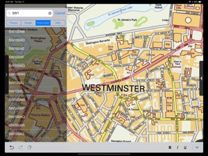
- Offline search functionality with searchable locations (places, roads, post codes and hills). (For the place search a location's latitude and longitude is accurate to 0.1 of a minute of the centre point of the 1x1 km National Grid square in which the name falls)
- Detailed hill information, including height, OS Grid Ref, latitude and longitude, region, parent, classification, drop and hill specific links to Streetmap, Geograph and Hill Bagging web sites
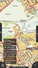
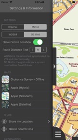
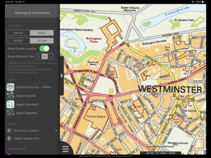
- Display of current GPS position as OS Grid Reference or WGS84 latitude and longitude
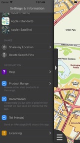
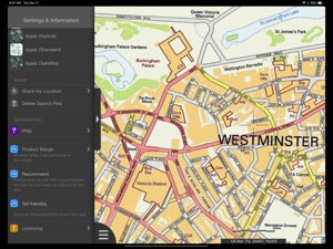
- "Share My Location" allowing users to share an image of their current location and location references.  Buttons are provided to share location information by Facebook, Twitter, iMessage/SMS and e-mail
- Online access to worldwide Apple Standard, Satellite and Hybrid maps
- Apple 3D Buildings are displayed on Apple Standard maps
- Apple maps contain Points of Interest
- User location can be tracked with or without heading on all online and offline maps (GPS capable devices only)
- Display of scale bar in either metric or imperial units
- Display of current speed
- Zoom, pan, rotation of all maps
- Pitch of Apple Standard and Ordnance Survey maps
- Selection of current location annotation for display of speed and location data
- User setting for speed display in Miles per Hour (mph) or Kilometres per Hour (kph)
- Selection of search result pin annotations to display location information
- Collective deletion of search result annotation pins
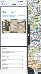
- A user guide is provided within
The OS search data was published by Ordnance Survey in 2014.
Extracts from "The Database of British and Irish Hills" v14 published 22/04/2014 (ref. http://www.hills-database.co.uk/index.html )
No warranty
The data is supplied by Apple, Ordnance Survey and Database of British and Irish Hills.
The Information is licensed 'as is' and the Information Provider and/or Licensor excludes all representations, warranties, obligations and liabilities in relation to the Information to the maximum extent permitted by law.
The Information Provider and/or Licensor are not liable for any errors or omissions in the Information and shall not be liable for any loss, injury or damage of any kind caused by its use.
This app is not a substitute for a paper map and compass.

What's New in Version 2.0.0

User Interface improved. Support to Route/Waypoint added. Support for larger displays added. User Guide added.
If you like the app, please leave a review rating and comment on the App Store.

Seller

Name

JOMO Solutions Ltd.

Information

Categories

Version

2.0.0

Size

535 MB

Game Center

No

VPP Device Licensing

Yes

Rating

Rated: 4+

Compatibility

iOS 8.0 or later

Devices

iPhone 11 Pro Max, iPad Air 2 (Cellular), iPad mini Retina (Cellular), iPad Pro (11-inch), iPad (5th Generation) Wi-Fi, iPad (6th generation) Wi-Fi, iPod touch (6th Generation), iPad Pro (11-inch) Wi-Fi + Cellular, iPad (6th generation) Wi-Fi + Cellular, iPad Pro 12.9-inch (3rd generation), iPad (5th Generation) Wi-Fi + Cellular, iPad mini (5th Generation) Wi-Fi + Cellular, iPad mini (5th Generation), iPad Pro, iPad mini 3, iPad mini 4 (Cellular), iPad mini 4, iPhone 11, iPod touch (7th generation), iPad mini 3 (Cellular), iPad Air, iPad Air 2, iPad Pro 12.9-inch (2nd generation), iPad Pro (Cellular), iPad Pro (9.7-inch) (Cellular), iPad Pro (10.5-inch) Wi-Fi + Cellular, iPad Pro (9.7-inch), iPad mini Retina, iPad Air (Cellular), iPad Air (3rd generation) Wi-Fi + Cellular, iPhone 6 Plus, iPad Air (3rd generation), iPad Pro (10.5-inch), iPad Pro 12.9-inch (2nd generation) Wi-Fi + Cellular, iPhone 6, iPhone XR, iPhone XS, iPhone 6s, iPhone SE, iPhone 7 Plus, iPhone 6s Plus, iPhone 5s, iPhone X, iPhone 8, iPhone XS Max, iPhone 8 Plus, iPhone 7, iPhone 5, iPad (7th generation) Wi-Fi, iPhone 5c, iPad (7th generation) Wi-Fi + Cellular, iPad Air3, iPad Air3Cellular, iPad Mini5, iPad Mini5Cellular, iPhone 11 Pro, iPad Pro 12.9-inch (3rd generation) Wi-Fi + Cellular, Watch4

Languages

English

App Store: Customer Ratings

Ratings & Reviews

4.5 of 5 (3 Ratings)

App Store: Customer Reviews

2017-08-04

Amazing

Who needs a satnav when you got a map like this.
I take my hat off to you. Fantastic.
The bondog
Version 1.3.0
2016-10-24

Great..

If you drive London, great level of detail when zoomed in..Offline too!
Paul161
Version 1.3.0
2015-09-12

Brilliant App.

After finding 'Lake District Maps' so fantastic,I just had to try LONDON Maps online, another great App from Jomo Solutions.
Can't wait to use it on our next visit to London. The detail is incredible. Thank you very much.
Woodielbas
Version 1.3.0
2015-05-23

Fantastic detailed maps

The level of detail on these maps is great with more detail added as you zoom in. The search is great too allowing the search of any road, postcode or place (not sure how many hills there are in London though). I definitely recommend this app.
Und3rTh3Sky
Version 1.3.0
2015-05-17

The only London map you will need!

Forget those paper maps, this is the only London map you will need! Very detailed, accurate and easy to use.
PeteTheCheat
Version 1.3.0
2015-05-08

Brilliant

The share my location feature is cool the way it updates the house number as you drive down a street looking for an address.
Ali Jock
Version 1.3.0
2015-05-05

Excellent detail

Brilliant. Goes right down to street level and even shows building outlines for a vast area. Definitely worthy of a 5* rating.
Mikegggggsssssss
Version 1.3.0
2015-03-09

This apps greatest secret

My part time job as a trainee covert operative means I am often forced to go off the grid to avoid having my movements tracked and having to deal with a whole lot of heat.
However this has often left me in the position of being unable to locate myself within this fair city. Unfortunately I am no Cartography Specialist, but thanks to this app I was able to get from The Apple Store on Regent Street to the Starbucks at Trafalgar Square in time to deliver the briefcase to Alfonso and save the world without Dr Wolfstrater being able to track my movements.
The public will be forever unaware of how for a brief time, the fabric of western civilisation rested on my shoulders, and how this little app played it's part in maintaining democracy in the free world. Thankyou Jomo
Richard_Howard
Version 1.2.0
2015-02-21

Excellent

Really easy to use and a fantastic help for getting around London
Hin7625
Version 1.0.0
2015-02-11

Great pair of apps

I was turned onto this after using the developer's Lake District one. I'm going up to London this weekend and seeing the sights so this should come in handy. I'm currently using an iPhone 4 but hope to upgrade soon to get all the other features on this app.
Stevie Cameron
Version 1.0.0